Erciyes, Kayseri
|
In order to ascend the Buyuk Agri and Cilo-Sat ranges, foreign mountaineering grups must have special permission from the proper authorities. For more information and to contact such Turkish groups, apply to the :
Ministry of Foreign Affairs Ankara.
Phone : +90(312)2125125, Fax : +90(312)2128966.
Youth and Sports General Directorate Mountaineering Federation
(Genclik ve Gen.Mudurlugu, Dagcilik federasyonu Bsk.)
Sanayi Cad.Nuzhet Atav ishani 28/2 Ulus-Ankara
Phone : +90(312)3101578-3090292 (4 lines) int (106-107)
Fax : +90(312)3101578
It is generally advisable to inform the Turkish Mountaineering Club, of the region and time of the intended climb, before the trip The Club will then inform the relevant authorities in the region so that they will be prepared to assist, should it be necessary.
Erciyes Mountain : This extinct volcano, the highest peak (3917 m) in central Anatolia, lies to the south of Kayseri. The Tekir Plateau is a recreational area in summer and a good sikiing area in winter and its reached via Hisarcik. The plateau is also the starting point for ascending the peek from the north face. The climb there and back takes about 10-12 hours, and on the plateau is a 100-bed capacity chalet Another route goes over the glacier called Sutdonduran.
|
Bey Mountains : These mountains are situated west of Antatya and reach a height of 3086 meters. The best starting points are from Antalya-Kemer and Antalya-Elmali.Climbing is possible year round. The trip to the top of Kizlar Sivrisi (3070 m) and back can be made in a day by camping in Sedir forest. Tahtali (2344 m) can be reached from Kemer. Driving to Soguk Pinar and camping there, the climb is made easily. The view of the Mediterranean from the top attracts many climbers.
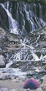
Kackar Mountains : Stretching for 30 km parallel to the Black Sea between Rize and Hopa, these ranges have peaks up to 3932 m in height with numerous glaciers, lakes, forests and hot springs. The mountains are divided into four massifs : Vercenik, Kackar (Kavron), Altiparmak and Hunut. Although all of these massifs have camping, climbing and hiking areas, the most popular of these treks is the Trans-Kackar route starting from the Ayder village, known for its beauty and hot springs. You may travel by car to the west to enter the foothills of the Trans-Kackar route all the way up to Asagi Kavron, where you continue on foot from Yukari Kavron to the Bogazcayiri natural camping area. From here, the summit of Kackar is about 7-9 hours trek at an altitude of 3932 m. When you corne down on the Eastern side you can also visit the Buyuk Cay Valley going on to Yaylalar Village and from there again by car on to Barhal. This entire area is known for its friendly peoble and hospitable neighbours.
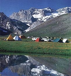
Ala Mountains : Situated 60 km southeast of Nigde, running in an easterly direction, the Yedi Goller Plateau lies at 3100 m and is surrounded by high peaks. The ideal season for ascending is Jun-September and the mountains are accessible via Nigde, Camardi and Cukurbag. The starting point for ascending the Demirkazik at 3756 m (there and back 9-10 hours is Sokullupinar,about 3 hours walk from Cukurbag. Starting from Yedi Goller Vadisi (Valley of the Seven Lakes) one can ascend up to Kizilkaya (3725 m, there and back in 10 hours), and Direktas (3470 m -10 hours). For ascending in the Kaldi group, the highest peak of which is 3734 m, the base camp should be made on the Sinekli Plateau.
Hasan Mountain : Situated south of Aksaray at a height of 3250 m, Hasan Mountain is accessible from all directions.The ideal starting points are Taspinar on the Ankara - Adana road and the village of Helvadere in the Ihlara Valley. Route plans and mountaineering guides are available from the Tourist Information Offices of the respective regions.
|
Aladaglar, Nigde
|
Bolkar Mountains : They are situated in the middle of the Toros Mountains. Lying on the Ankara - Adana road. The best starting points, in order to reach the peaks of Kizilyar (3854m) and Turasan (3499 m), are Maden Koyu near Ciftehan and Elmapinar near Camalan.
Buyuk Agri Mountain : This is the highest mountain (5137 m) in Turkey with its peak totally capped by a glacier. The best seasons are July - September. Dogubayazit is the starting point for climbing the southern face, via the village of Topcatan. A plateau leads to this highest point(5137,5m) in Anatolia. The mountain is also legendary for its friendly people.
Suphan Mountain : This is the third highest peak (4059 m) in Turkey and has a crater lake. Starting from Adilcevaz the trip to the top and back takes about three days.
Mercan (Munzur) Mountains : Ranging from 3462 m to 3500 m, this range lies between Tunceli and Erzincan. The highest peaks are north of Ovacik.
Cilo- Sat Mountains : This range, located in the east has numerous glaciers, lakes and streams, so it is an ideal region for mountaineering and rambling. The best season for climbing and hiking is Jun-September. The starting point is the high plateau of Mercan, 5 hours walk from the gendarme post of Zap (18 km from Hakkari). Access to the Gelyasin Peak (4135 m) is via the high plateau of Serpil and access to the Kisara Peak (3752 m) is via the village of Kursin and So. The track to the Samdi Peak and the surrounding glaciers starts from the "Sat Gevaruk" Pasture. The galcier lake Bay Golu surrounded by alpine flora lies at 2700 m.
|
|